ホステル ブリケットからの山頂ハイキング
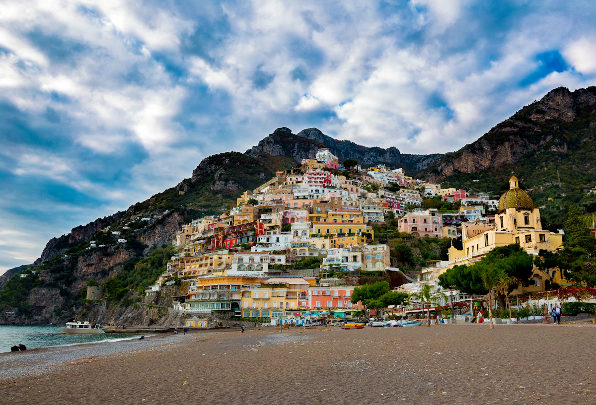
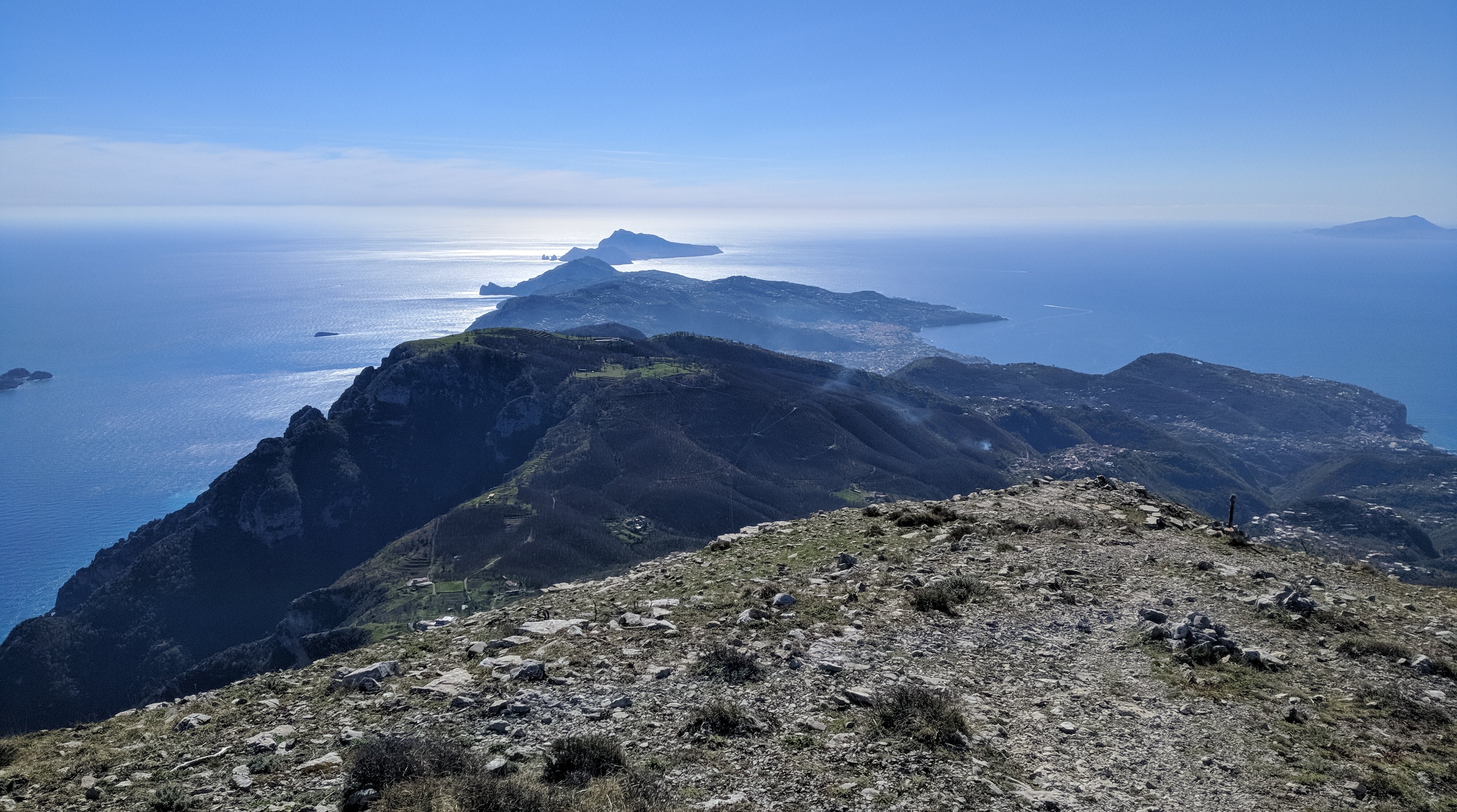
Monte Sant'Angelo towers above the Amalfi Coast and rewards hikers with sweeping 360-degree views stretching from Capri to the Sorrentine Peninsula.
This itinerary starts from Hostel Brikette, guides you up to Santa Maria del Castello, and explains the final push to the summit so you know exactly what to expect before committing.
Why tackle this hike
Views from the summit sweep across the peninsula towards Capri and down the Lattari mountains, making the grind worthwhile for photographers and hikers alike.
Reaching the Amalfi Coast's highest point is a satisfying physical challenge and a story you will trade with other travellers back at the hostel.
The long ascent doubles as a serious cardio session, especially if you are training for bigger treks later in your trip.
Getting to Santa Maria del Castello
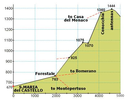
Follow our standard hostel-to-Santa-Maria directions until you arrive in the village; that climb covers just over one third of the total elevation for the day.
Take a breather in the square, refill water if the bar is open, and check that everyone in your group still feels strong before committing to the exposed upper trail.
From Santa Maria to the summit
From the crossroads at the top of the village, turn right up the paved lane until a junction, then turn left and continue past the restaurant until the road bends sharply left.
Leave the road on the right-hand side, following the side path that drops slightly between houses. It will feel like private property at first, but you are still on the right track.
Stay on the mountain trail for an extended stretch until you reach a signed crossroads. Ignore the downhill options and take the steeply rising path.
The ascent quickly zig-zags before easing into a long, flatter traverse along the left-hand side of the mountain face. When you spot stone-cut steps on your right, follow them around the back of the peak for the final push.
Those rock steps lead to the last ramp of the day—keep climbing and you will emerge on the summit plateau with panoramic views in every direction.
Getting to Santa Maria del Castello
Follow the Santa Maria del Castello hike guide directions until you arrive in the village; that climb covers just over one third of the total elevation for the day.
Take a breather in the square, refill water if the bar is open, and check that everyone in your group still feels strong before committing to the exposed upper trail.
Santa Maria → summit (photo guide)
Use this photo to orient yourself before leaving Santa Maria — the upper route is long, markers are sparse, and it’s much easier if your group agrees on the key turns at the start.
Directions from Santa Maria to the Mountain Top
From the crossroads at the top of the village, turn right up the paved lane until a junction, then turn left and continue past the restaurant until the road bends sharply left.
Leave the road on the right-hand side, following the side path that drops slightly between houses. It will feel like private property at first, but you are still on the right track.
Stay on the mountain trail for an extended stretch until you reach a signed crossroads. Ignore the downhill options and take the steeply rising path.
The ascent quickly zig-zags before easing into a long, flatter traverse along the left-hand side of the mountain face. When you spot stone-cut steps on your right, follow them around the back of the peak for the final push.
Those rock steps lead to the last ramp of the day—keep climbing and you will emerge on the summit plateau with panoramic views in every direction.
コンテンツ
- 1 人あたり少なくとも 2 リットルの水と塩味の軽食。サンタ・マリア・デル・カステッロの後には信頼できる補充はありません。
- グリップ力のあるしっかりしたハイキング シューズ。上部のトレイルのセクションは岩が多く、緩んでいて露出しています。
- 頂上での日焼け止めと重ね着。暖かい日でも風が尾根を越えることがあります。
典型的なコスト
- トレイルへのアクセスは無料です。サンタ マリア デル カステッロで自分へのご褒美に飲み物や軽食を楽しみたい場合は、予算 €5 ~ €10 をお勧めします。
- ハイキングをせずに別の村を経由して下山する場合は、SITA バスのチケットまたはフェリーの運賃を返却してください。
スマートタイミング
- 夏は、最高の暑さの下での登山を避けるために夜明けから出発します。晩秋と春の午後は、灼熱の太陽がなく、柔らかな光が差し込みます。
- 嵐の予報を確認してください。雲がかかると景色が見えなくなり、濡れた石が頂上の階段を滑りやすくなります。
- 出発前にホステルのスタッフに計画と帰宅予定時刻を知らせてください。
Step by step
- Climb to Santa Maria del Castello: ホステルのサンタ マリア デル カステッロ行きのルートをご利用ください。広場に到達すると、標高のおよそ 3 分の 1 を完了したことになります。
- Join the mountain trail: 村の交差点から右折し、レストランを過ぎて左折し、家々の脇を通る右側の道に車道を出ます。
- Commit to the upper ascent: 標識のある交差点まで険しい道を進み、頂上に向かって真っすぐに登る道を選択してください。
- Navigate the zig-zags: 山の左側面に沿って道が平らになるまで、急なスイッチバックを通過します。
- Take the rock-cut stairs: 右側の石段を登り、山肌の裏側を回りながら最後のランプまで進みます。
- Reach the summit: 頂上への最後の登りをたどってパノラマを楽しみ、その後サンタ マリアへの道を戻ります。
よくある質問
How long does the full hike take?
サンタ マリアでの休憩と頂上での時間を含め、ホステル ブリケットからの往復には 6 ~ 7 時間かかります。
Is the trail marked?
サンタマリアを越えるとマーカーはまばらです。オフライン地図を携帯し、明らかに磨耗した道や交差点の標識に注意してください。
Can I turn back early?
はい。上部が露出しすぎていると感じる場合は、サンタマリアまたは下部のスイッチバックからの眺めを楽しみ、来た道を戻りましょう。